Project background
During the 2022 consultation, the community raised a need for traffic calming treatments on O'Brien Street. The local area traffic management (LATM) study, carried out by consultants GHD, analysed a number of data sources. Ones relevant to O'Brien Street were history of crashes and serious Injury probability risk.
Crash History Data
Intersecting roads with high concentrations of incidents include the intersection (roundabout) of Lamrock Avenue/Barracluff Avenue and O’Brien Street which included one serious injury incident.
Site Observations
During site visits it was observed that the O’Brien St / Barracluff Avenue roundabout configuration does not manage vehicle speeds. Where it was observed, particularly in the eastbound direction, vehicle speeds were maintained and not reduced through the roundabout.
Near Miss Data and GPS Location and data of Near Miss Sites
Near miss data and display incidents of vehicle data where high g-forces (due to braking or swerving) were recorded. It is possible that braking and swerving actions arise from interactions with other vehicles, or incidents with pedestrians and cyclists. Individual near misses were recorded on several locations, including on Barracluff Avenue.
Intersection alignment and/or features at Barracluff Avenue at O’Brien Street could be altered in order to improve safety for pedestrians and vehicles.
- 85th percentile speed: 40 km/h (source: Compass IoT)
- 4 crashes recorded at the location between 2017-2022 (1 serious injury) (NSW Centre for Road Safety)
- High relative kinetic energy distribution and relative density assessment around the intersection from Compass data (indicative of high vehicle approach speeds and/or volume of heavy vehicles)
- The existing roundabout does not induce sufficient horizontal deflection to reduce approach vehicle speeds, based on observations and data analysis
- Poor state of repair of the roundabout and inconsistent road surface identified.
What is compass IOT data? - Compass IoT data refers to anonymized and aggregated connected vehicle data collected and analysed by Compass IoT, an Australian road intelligence company. This data is used to improve road safety, infrastructure, and city planning. It's collected from a vast network of vehicles, providing insights into road conditions, traffic flow, and driver behaviour without identifying individual drivers
Noting the outcome of the study, traffic calming treatment options are to be investigated to reduce traffic speed. Safer crossings for pedestrians to be reviewed and travel for vulnerable road users to be improved at the intersections of Lamrock Avenue, Barracluff Avenue and O’Brien Street.
Considerations
Traffic calming treatments – investigate speed cushions, road humps, chicanes, line marking, kerb buildouts
- Parking gain/loss – maintain and or/increase where possible, justification required if parking loss.
- Pedestrian movements and crossings – review main pedestrian movements at intersections and look to improving crossings, where possible.
- Cyclists – review cyclist movements and improve routes and crossings
- Green space – where the design increases open spaces, identify areas of planting and/or trees.
- Note residents' driveways and access – whilst developing the design, note driveway access movements.
Traffic modelling was undertaken for this intersection, based on traffic surveys undertaken in February 2025. The assessment outcome is representative of a relative peak period at Bondi Beach.
Existing intersection - Currently, this intersection operates at a reasonable level, and there are no major delays or queueing in either the morning or afternoon peak.. The queues for vehicles exiting Barracluff Avenue often extend past the Lamrock Avenue/ Barracluff Avenue intersection. However, this is due to the small offset between these intersections (~10 metres).
Proposed option - The modelling shows that the intersection will see a very minor decrease in performance for vehicles, as a result of the proposed changes. It is not to a level where action is required to improve the performance. The expected benefits from priority crossings for pedestrians are significant. Overall, the proposed intersection change does not severely impact traffic congestion along O’Brien Street and the expected benefits from priority crossings for pedestrians are significant.
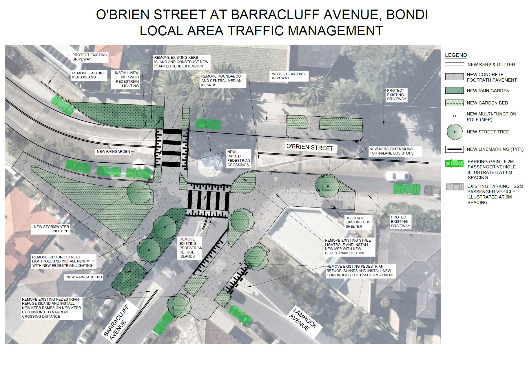
Removal of Roundabout and upgrade intersections. The existing roundabout does not induce sufficient horizontal deflection to reduce approach vehicle speeds, based on observations and data analysis.
New planted kerb islands with opportunity for street trees. These will provide traffic calming, slowing vehicles by narrowing the roadway. They also improve visibility for all road users, particularly as people often cross at these locations. Providing extended areas of kerb allows for drivers to better identify pedestrians about to cross, and pedestrians to better identify a driver before they cross. There is concern that street trees limit visibility, however, this is dependent on species. This is to be determined in the detailed design phase.
New continuous footpath treatment (CFT) at Lamrock Avenue. CFT’s slow down traffic in a similar way to a speed hump, making vehicles slow down to navigate the vertical rise. They also provide priority for pedestrians, as drivers must give way.
New raised pedestrian crossings across Barracluff Avenue and O’Brien Street. Raised crossings slow down traffic in a similar way to a speed hump, making vehicles slow down to navigate the vertical rise. They also provide priority for pedestrians and cyclists, as drivers must give way.
Parking. The design has potential to increase the available parking supply by approximately 8 additional car parking spaces.
New in-lane bus stops on O’Brien Street. In-lane bus stops provide priority for busses, as they do not have to re-enter the travel lane after stopping. This is an important benefit on a high frequency, high usage, bus route such as the 379.