Project Background
In 2022 during the consultation, the community raised a need for traffic calming treatments on Wellington Street. Congestion was also noted as an issue.
The local area traffic management study, carried out by a consultant, GHD, analysed a number of data sources. Ones relevant to Wellington street: traffic speeds, traffic volumes, high fatality and serios Injury probability risk, Near Miss Data and GPS Location and data of Near Miss Sites.
Traffic Volumes
Traffic counts were commissioned by Waverley council. Wellington Street was one of the highest traffic volume roads within the study area.
Traffic Speeds
An analysis of the 85th Percentile Speed Distribution from the Compass IOT data indicate that speeds are between 35km – 50km on Wellington Street between Bondi Road and O’Brien Street. 85th percentile speed: 47 km/h (source: ATC).
During the traffic counts data work a higher proportion of vehicles exceeding the speed limit is also observed on Wellington Street (between Francis Street and O’Brien Street) on weekdays and weekends.
High fatality and serious Injury probability risk
The study revealed additional high fatality and serios Injury probability risk (FSI) probability on Wellington Street, between Francis Street and O’Brien Street. This data can inform – in conjunction with other data and considerations (crash history data and findings from site visits and community) – where opportunities for the installation of traffic management treatments may be recommended to improve safety for traffic and vulnerable road users.
Near Miss Data and GPS Location and data of Near Miss Sites
Near miss data display incidents of vehicle data where high g-forces due to braking or swerving were recorded. The braking and swerving actions recorded are possible to arise from interactions with other vehicles or incidents with pedestrians and cyclists. Individual near misses were recorded on several locations, including on Wellington Street.
Key concerns of residents about this location:
- 85th percentile speed: 47 km/h (Source: ATC)
- Segments of high traffic speeds - Between Francis St and O’Brien Street (Compass IoT data)
- High traffic volumes from survey data
- Three vehicle and two pedestrian incidents recorded at intersections with Francis Street and O’Brien Street (NSW Centre for Road Safety)
- High FSI risk, relative density and kinetic energy distributions (Compass IoT data)
- Near miss data recorded
Statistics for the GHD March 2024 report were before the speed reduction to 40km/h on Wellington St, which was introduced in October 2024. The traffic team re-ran the section of Wellington St between O’Brien St and Francis St (where these works are proposed) on Compass IOT for an equivalent period after the speed limit change. This indicated that the 85th percentile speed along this section has been largely unchanged because of this speed limit change. This reinforces the need for additional traffic calming measures on Wellington St.
What is compass IOT data?
Compass IoT data refers to anonymized and aggregated connected vehicle data collected and analysed by Compass IoT, an Australian road intelligence company. This data is used to improve road safety, infrastructure, and city planning. It's collected from a vast network of vehicles, providing insights into road conditions, traffic flow, and driver behaviour without identifying individual drivers
Image 1 of 3
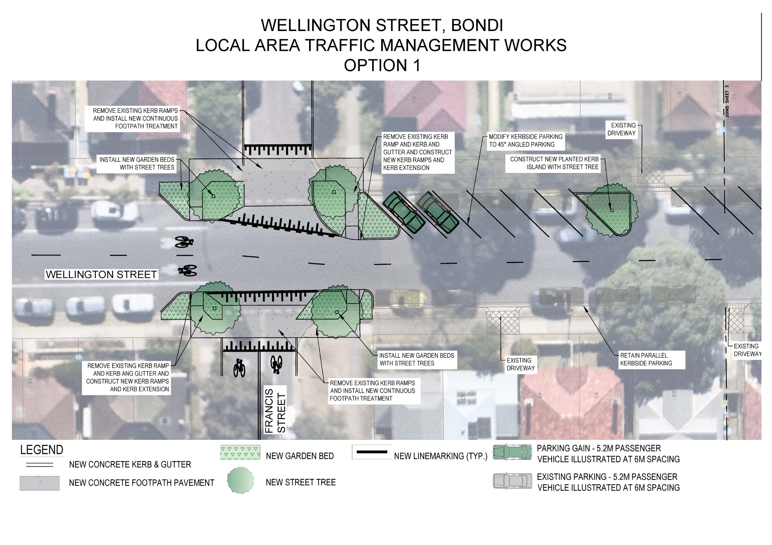
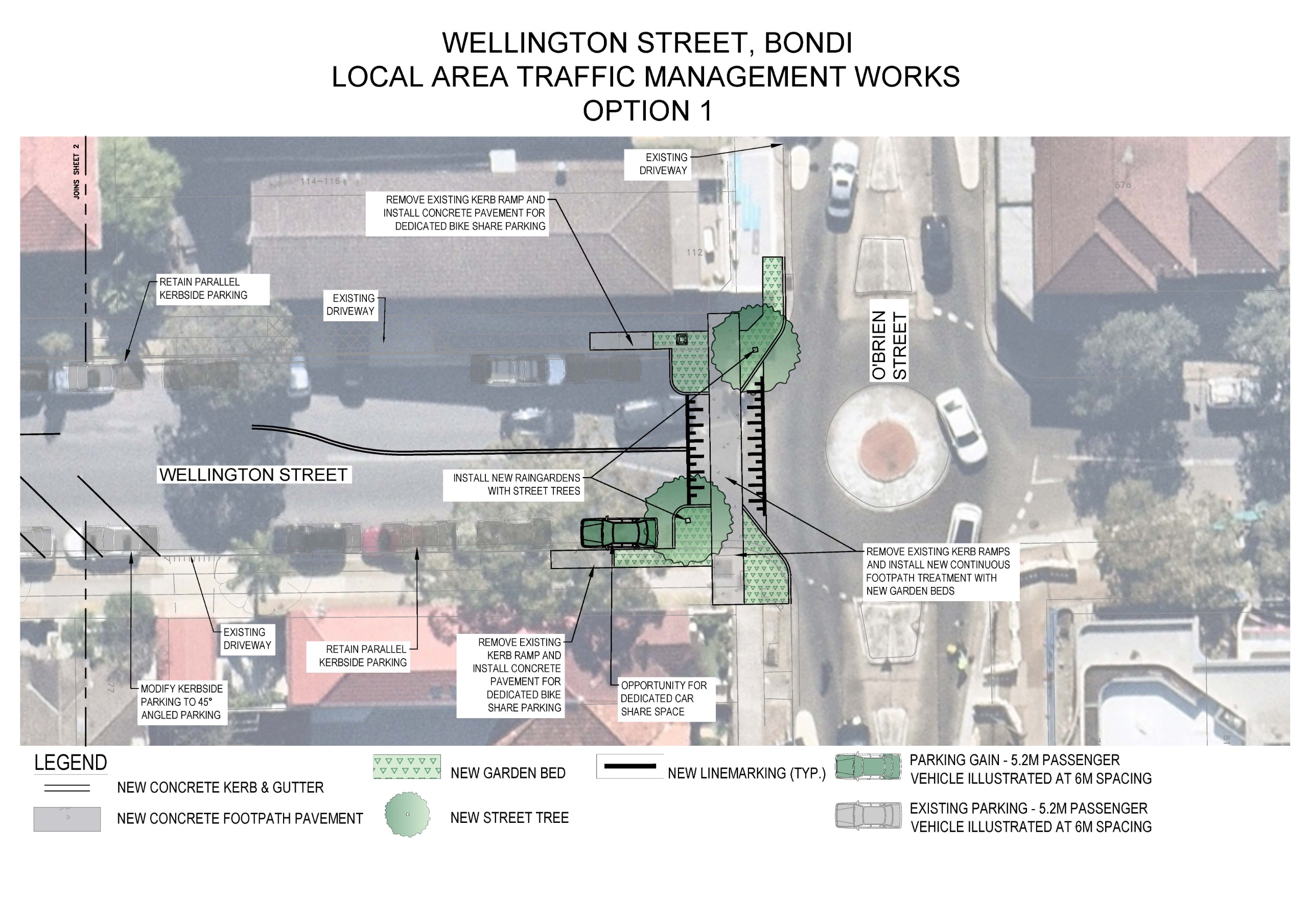
- New kerb buildouts at Francis Street and O’Brien Street, with new garden beds and kerb ramps. These will provide traffic calming, slowing vehicles by narrowing the roadway. They also reduce the required distance to cross for pedestrians making it safer and easier to cross the road.
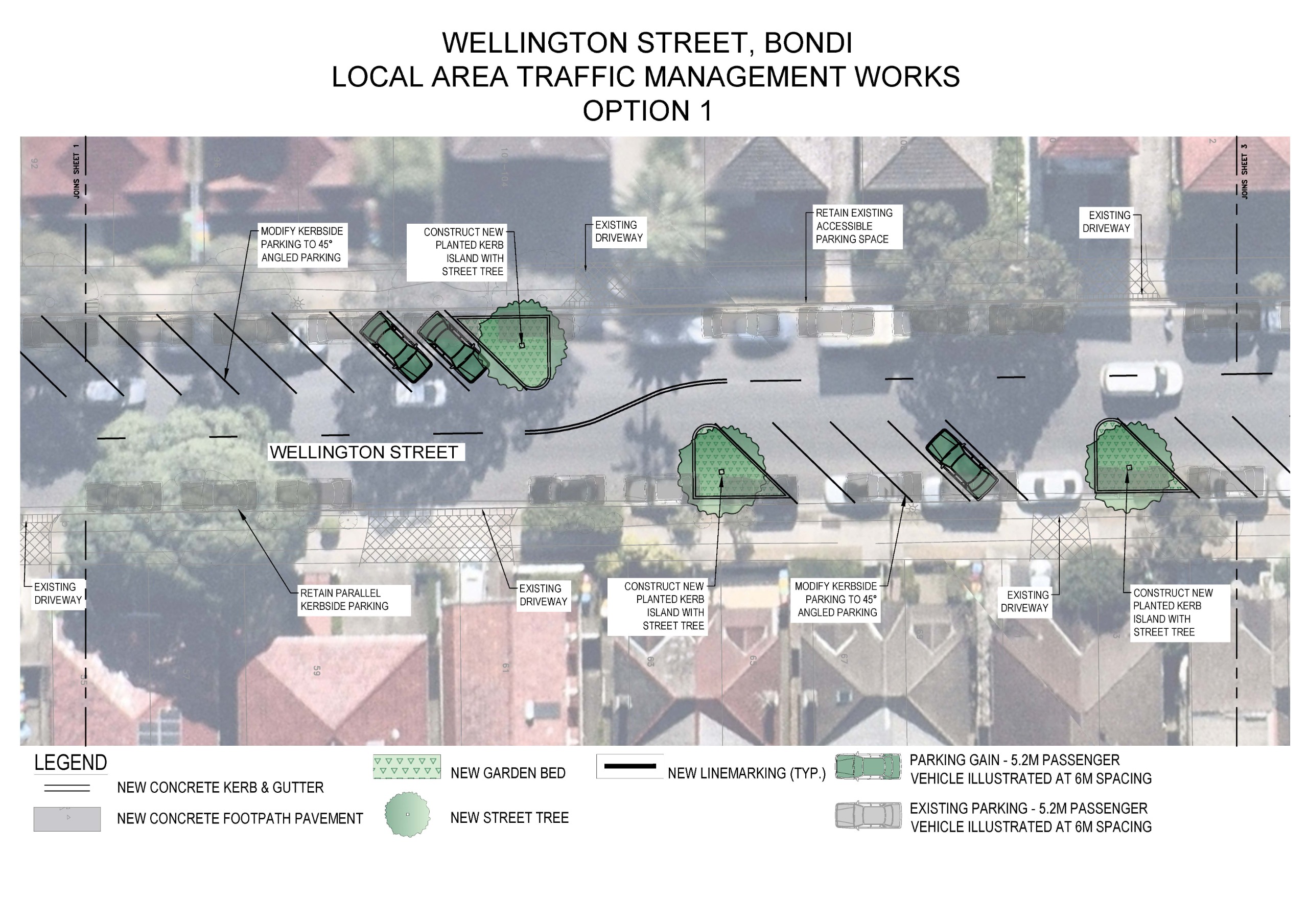
- Alternating sections of existing parallel parking modified to 45° angled parking. This provides traffic calming through slowing vehicles with a narrowing of the roadway. This also increases the available parking supply by approximately 11 additional car parking spaces.
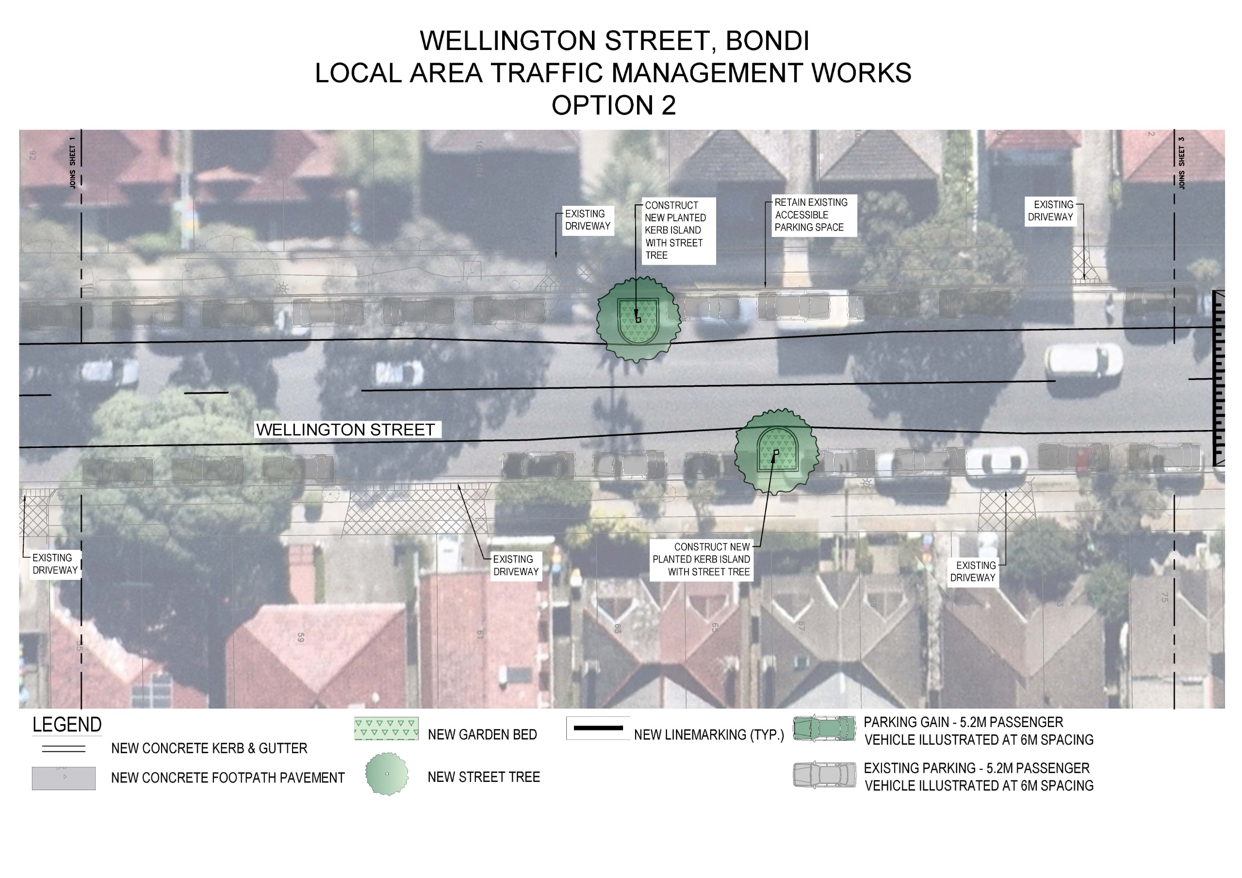
- New planted kerb islands with opportunity for street trees. These will provide traffic calming, slowing vehicles by narrowing the roadway. They also improve visibility for all road users, particularly as people often cross at these locations. Providing extended areas of kerb allows for drivers to better identify pedestrians about to cross, and pedestrians to better identify a driver before they cross. There is concern that street trees limit visibility, however, this is dependent on species. This is to be determined in the detailed design phase.
- New continuous footpath treatments (CFT) at Francis Street north and south and at O’Brien Street. CFT’s slow down traffic in a similar way to a speed hump, making vehicles slow down to navigate the vertical rise. They also provide priority for pedestrians, as drivers must give way.
Image 1 of 3
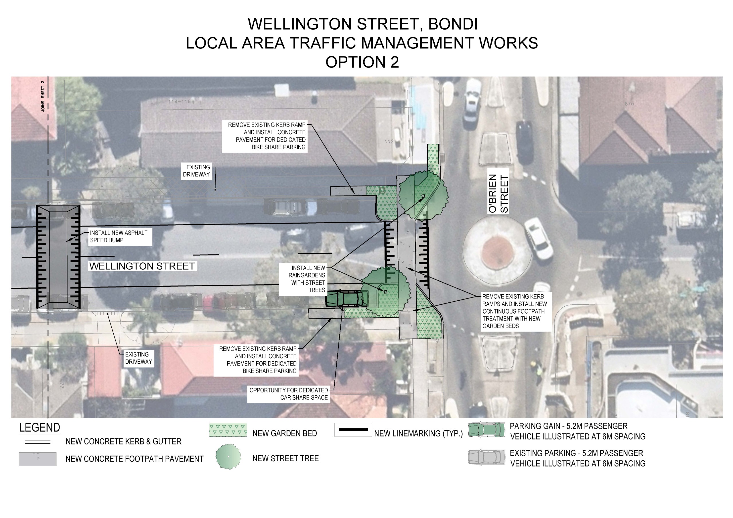

- New kerb buildouts at Francis Street and O’Brien Street, with new garden beds and kerb ramps. These will provide traffic calming, slowing vehicles by narrowing the roadway. They also reduce the required distance to cross for pedestrians making it safer and easier to cross the road.
- New continuous footpath treatments (CFT) at Francis Street north and south and at O’Brien Street. CFT’s slow down traffic in a similar way to a speed hump, making vehicles slow down to navigate the vertical rise. They also provide priority for pedestrians, as drivers must give way.
- New speed humps. Speed humps introduce a gentle incline for drivers to navigate. This requires a reduction in speed, minimizing the risk and severity of accidents on the road. Speed humps also help cyclists by reducing the speed of vehicles, which makes the roads safer by lowering the risk of serious accidents and increasing a cyclists reaction time.
- Narrower traffic lanes through edge line marking. Narrower traffic lanes encourage slower vehicle speeds, as drivers do not feel as comfortable travelling at high speeds.
- New planted kerb islands with opportunity for street trees. These will provide traffic calming, slowing vehicles by narrowing the roadway. They also improve visibility for all road users, particularly as people often cross at these locations. Providing extended areas of kerb allows for drivers to better identify pedestrians about to cross, and pedestrians to better identify a driver before they cross. There is concern that street trees limit visibility, however, this is dependent on species. This is to be determined in the detailed design phase.
- One additional car parking space with opportunity to allocate as a dedicated car share pod. Car share pods are an essential tool to effectively managing parking demand in the area. One car share pod frees up approx. 10 on-street parking spaces


